|
 Global
Positioning Systems (GPS) is the technology that allows
the mapping of location data such as timber stands or
tract/property boundaries using a GPS receiver and
powerful GIS software (refer to GIS
page). GPS technology
relies on the coordination between a series of 24
satellites in space and a GPS ground unit receiver that is
either usually hand-held or stored in a backpack. GPS
uses these satellites or "man-made stars" as
reference points to calculate positions accurate to a
matter of meters. With advanced forms of GPS you can make
measurements to better than a centimeter. At Reynolds
Forestry, we utilize GPS to determine stand boundaries and
all many aspects of daily activity. We derive the accurate
acreage from the collected GPS data which allows us
to draw the stand maps on digital topographic and aerial
maps as well as accurate billing. Global
Positioning Systems (GPS) is the technology that allows
the mapping of location data such as timber stands or
tract/property boundaries using a GPS receiver and
powerful GIS software (refer to GIS
page). GPS technology
relies on the coordination between a series of 24
satellites in space and a GPS ground unit receiver that is
either usually hand-held or stored in a backpack. GPS
uses these satellites or "man-made stars" as
reference points to calculate positions accurate to a
matter of meters. With advanced forms of GPS you can make
measurements to better than a centimeter. At Reynolds
Forestry, we utilize GPS to determine stand boundaries and
all many aspects of daily activity. We derive the accurate
acreage from the collected GPS data which allows us
to draw the stand maps on digital topographic and aerial
maps as well as accurate billing.

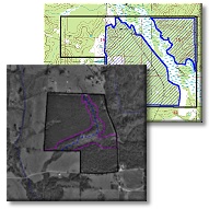
Collected GPS data overlaid
on
Aerial and Topographic map If
you would like to learn more about GPS, view the links
page. If you would like to learn more about how we use GPS
at Reynolds Forestry Consulting, please contact me using
the contact information at the bottom of the page. |
--Cropp.gif)